St. Peter's Churchyard Project
A project by Minsterworth villagers to record the graves and commemorative stones in St. Peter's churchyard, Minsterworth.

|
An up-to-date survey has recently been carried out of the churchyard, to map and identify the burial plots in St. Peter's Church, Minsterworth.
Led by the village's renowned historian, Terry Moore-Scott, and with great support from members of the village community, the project team has been established to record the current condition of the graves and augment the record with names, dates, and the survey work of Fulbrook-Leggatt who completed a chart and names listing in August 1954. In this survey, Fullbrook-Leggatt recorded the positions and a primary name for each plot. What was not listed at that time were the names, dates and relationships of others who were buried in the same plots. Since the initial survey, the churchyard has been extended to within a few yards of the River Severn's flood defence abutments, and a large number of new graves in that area of the churchyard have had to be recorded. The processed results of this work are listed in spreadsheet form using the zone designator letters used by Fulbrook-Leggatt in his original survey (A to F), with the churchyard extension area being a new zone G. The volunteer researchers have extensively surveyed the remains of gravestones and memorial stones to establish the history of each plot. The site, using Fulbrook-Leggatt's zoning system will be re-created in a large format chart, soon to be displayed in the church, allowing relatives and historians to discover where ancestors and people of note, were laid to rest. This will be accompanied by an interactive database to allow searchers easy access to the records to find relatives or memorial sites within the churchyard. |
|
Here is the downloadable image of the Churchyard (shown above)
|
| ||
In the downloadable MS Excel spreadsheet listing below (Survey_Jan_24 Including_Bigland_and_Memorials), the new survey results are currently being listed, initially in spreadsheet form.
Explanatory Notes
The information is presented as a single Excel spreadsheet, but in three parts:
1. By Zone and Plot.
Explanatory Notes
The information is presented as a single Excel spreadsheet, but in three parts:
1. By Zone and Plot.
- A listing of grave sites in the churchyard wherein the area is broken down into seven ‘zones’ A to G. Each grave site is numbered according to the zone it is in, and individually numbered using a sequential numbering system, e.g. B1,B2 etc, F23,F24 etc.
- Cremation plots are similarly labelled but with an extra ‘C’ in the prefix, e.g. CC1, CC2 etc.
- Recorded for each grave are the personal details taken from the gravestone of the primary individual and, where available, any additional family members commemorated. Included in the record also are numbered plots shown only as ‘mound’; these are derived from the last survey done in the 1950s by Fulbrook Leggatt and indicate that no further information is available.
- This historic information relating to Minsterworth church has been taken from Historical, Monumental and Genealogical Collections Relative to the County of Gloucester (section CLXXV) compiled by Ralph Bigland and published around 1786-91. It provides detailed information on monuments in the church as well as on tombs and headstones in the churchyard. Virtually all this information is additional to that given in part 1 above, and most of the memorials recorded no longer exist.
- Detailed information taken from memorials existing in the present church today. A few are earlier but most date from the late 19th century.
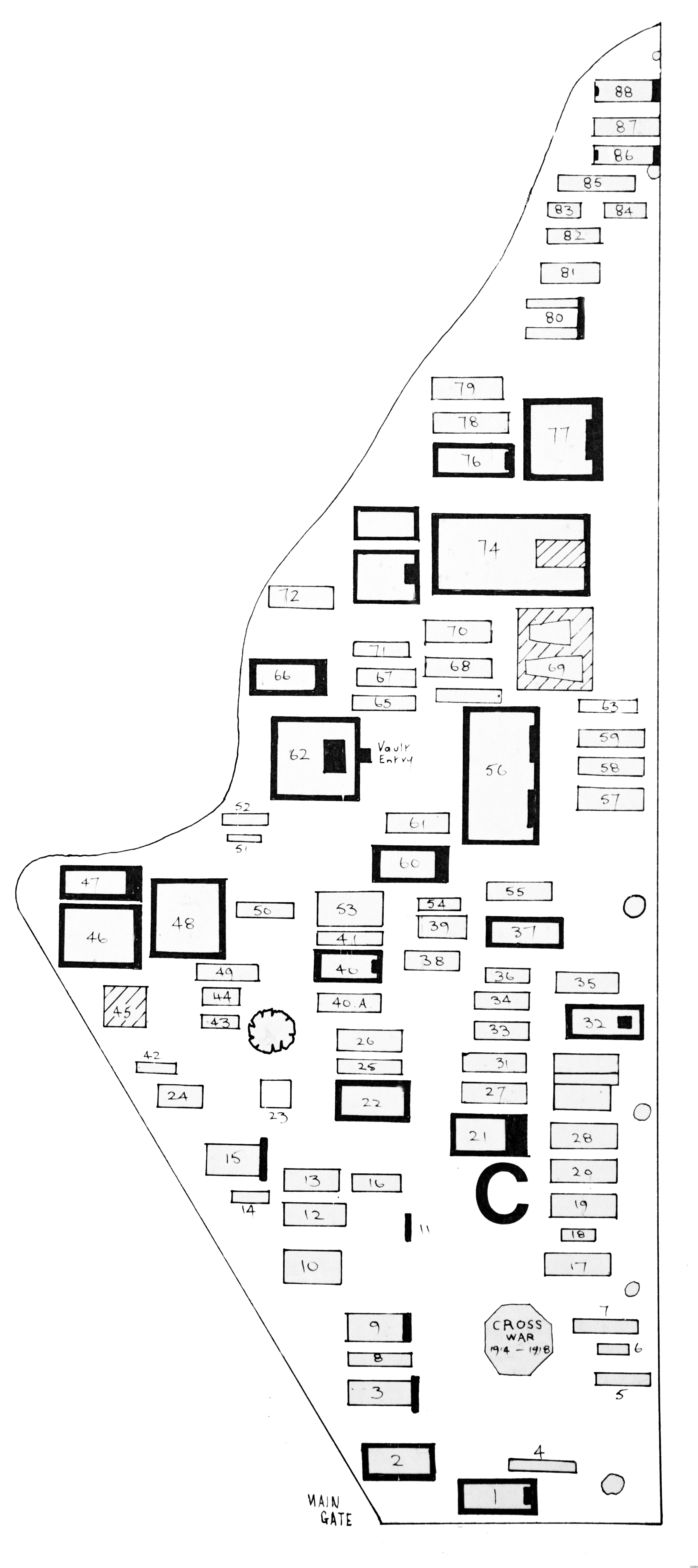
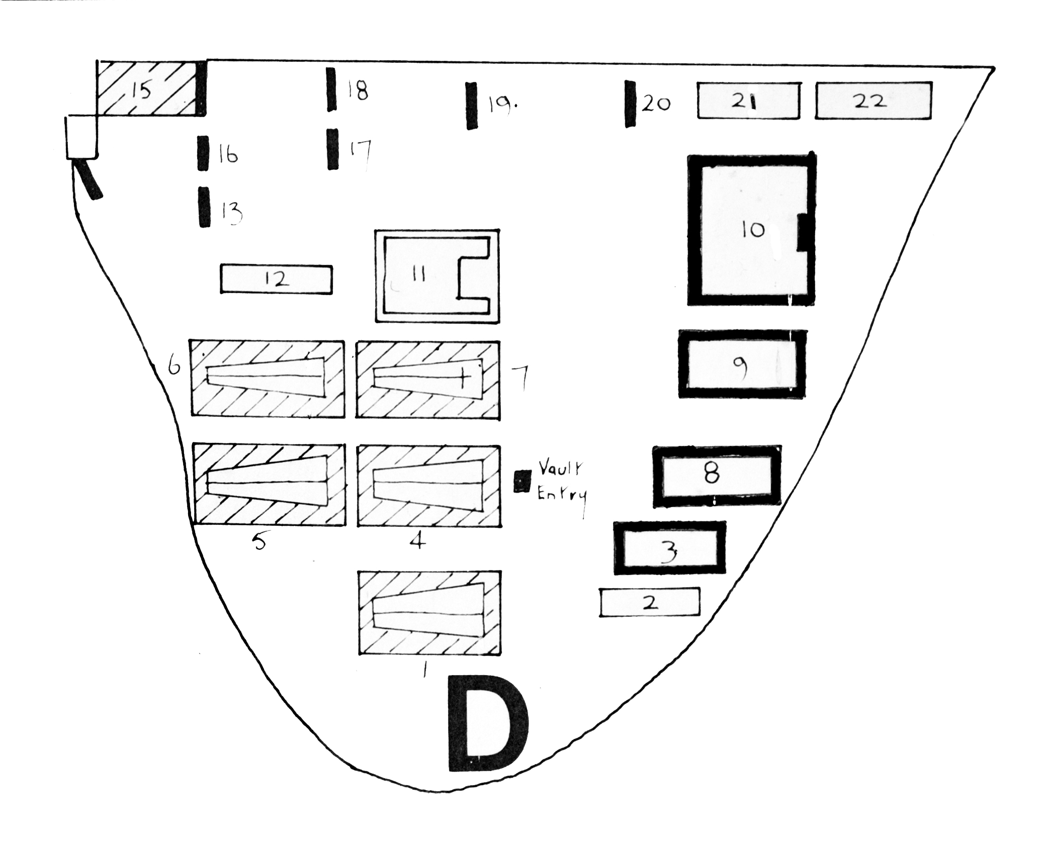
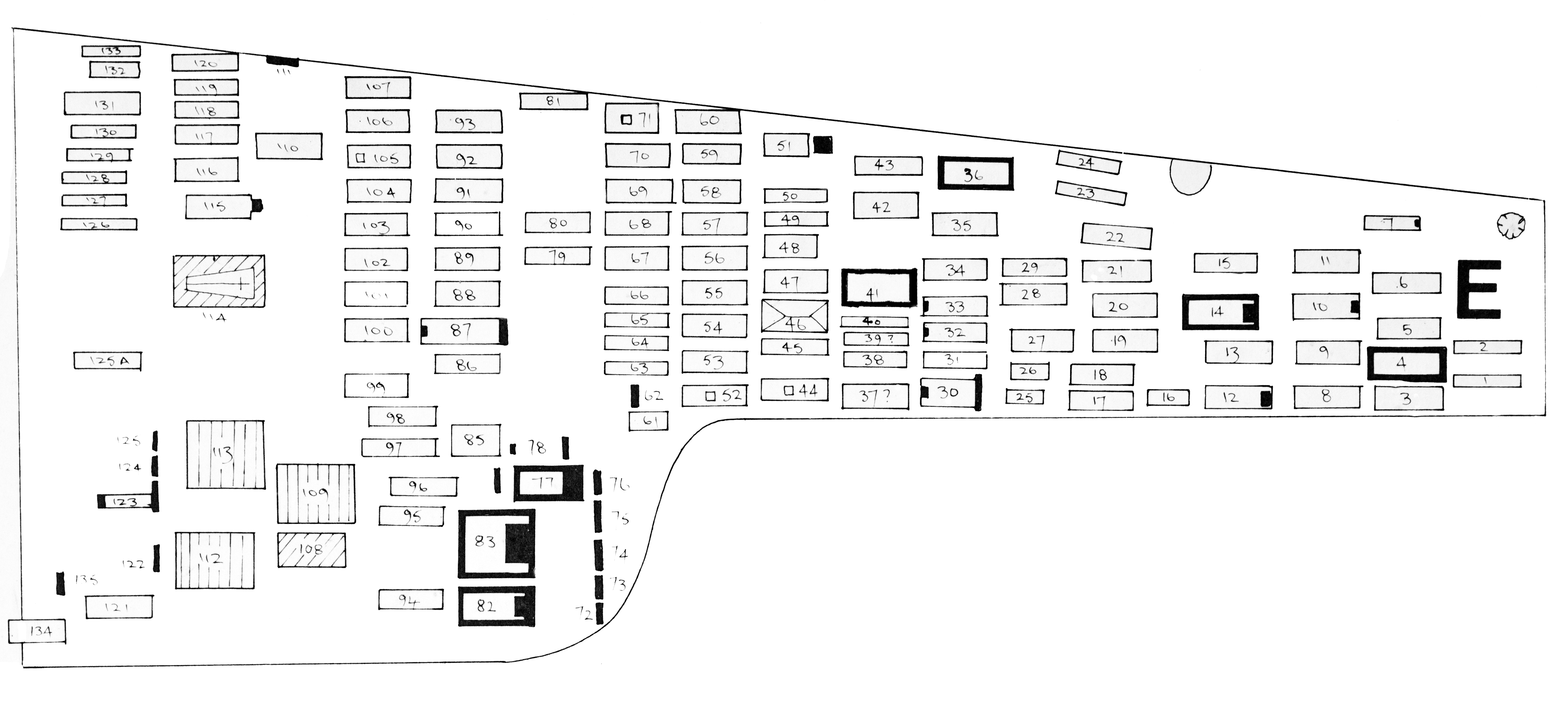
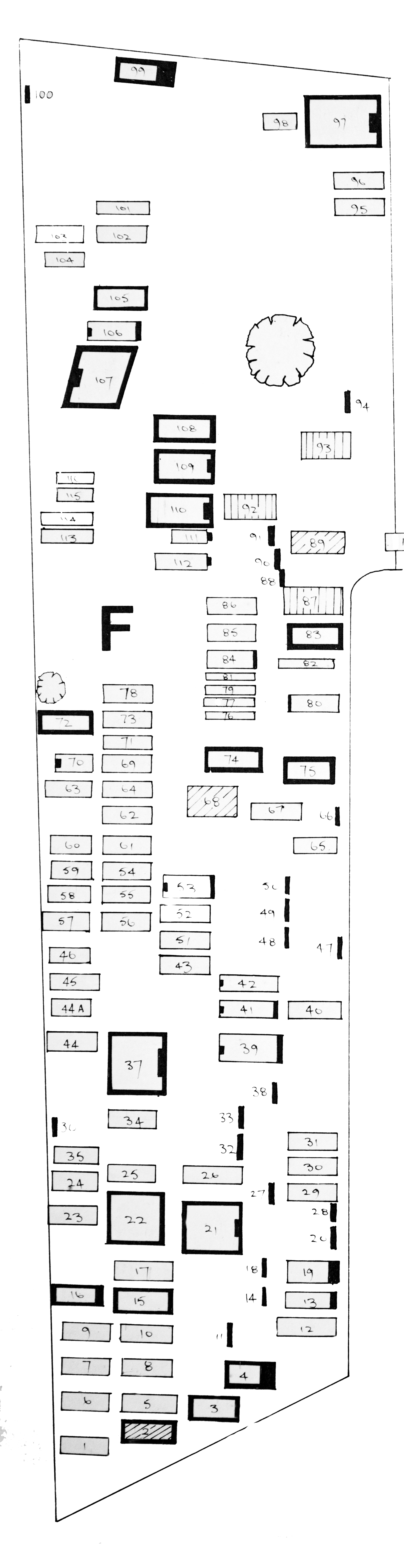
In this section, these files show plans of the zones, according to Fullbrook-Leggatt's records.
All zones, plus the recent "Zone G" can now be downloaded.
Use the file "Survey_Jan_24 Including_Bigland_and_Memorials" for the most up-to-date information
All zones, plus the recent "Zone G" can now be downloaded.
Use the file "Survey_Jan_24 Including_Bigland_and_Memorials" for the most up-to-date information
Please download the images below to your computer to view each zone
| survey_jan_24_including_bigland_and_memorials.xlsx |
|
|
| ||||||
|
|
| ||||||
| extension_zone_g.jpg |
This project will be further extended with images and descriptions of stones as the work progresses.
Here, the image of the gravestone of William Little, who died in 1699,
is believed to be the oldest surviving (and legible) headstone in the churchyard:
is believed to be the oldest surviving (and legible) headstone in the churchyard:
By using on-line programmes such as "Ancestry" it is possible to research a family tree.
Here is a brief example of research into William Little's tree:
Here is a brief example of research into William Little's tree:
The father of Louisa Hawkins - J. Hawkins - is buried in the churchyard, Zone C, grave number 109.
Louisa went on to become the wife of Sir Arthur Conan Doyle - Lady Doyle:
Louisa went on to become the wife of Sir Arthur Conan Doyle - Lady Doyle: